Route 66 - Day 3: St. Louis to Springfield, MO
On our walk this morning, we couldn't venture too far from the room since the door latch had stopped working the night before and I couldn't shut it. River showed me how to make the most of what grass and plants we could find while keeping sight of that door.
And I formulated a plan of attack for Route 66 today: I learned that it passed right by the St. Louis Gateway Arch, so I set my navigation with two addresses. One was the address for the Arch and the other was my final destination at the motel in Springfield. I planned to use the navigation to find the arch and then get on Route 66 from there sans nav. Theoretically, I could do that all the way to Springfield, or, if I get lost or bored, I could quickly turn the nav on and be guided to the motel room.
I found the arch and was delighted to discover that there was almost no traffic in downtown St. Louis. It was very peaceful compared to New York and Chicago and the arch itself was a lot bigger than I imagined. Even as I see this picture I took, I now know that it looks and feels much bigger than it looks in the photograph.

But there was no sign of Route 66 anywhere. I decided to fill up with gas and ask the clerk how to get there. I figured anyone in town would know exactly where to go. "How do I get to Route 66?" I asked him as I was paying for my gas.
Puzzled, he looked sternly at me and asked "Phillips 66?!" (This was a BP Station)
"No, I said, Route 66, the Historic Highway".
"Where you want go?" He asked impatiently. When I told him Springfield, he asked the requisite question, MO or IL? (I should've caught on to that one by now after how many times I got asked that last night.)
When I told him MO, he started to rattle off a bunch of highways, and I stopped him saying, "No I want to take Route 66." By this time another guy was standing behind me in line, so I asked him, "Do you know how to get to Route 66?"
He insisted that there is no such highway in town, but I insisted that there was and that it goes right by the arch. As I was explaining that to both of the men that you can't see it on the map because it's a ceremonial highway, a voice popped up from behind the chips, "Ah yes, that's the historic highway Route 66." So I perked up and scooted over to his direction and asked him to tell me what he knew. He was fuzzy on details but seemed to think that it went along a street called Gravois St. I got excited and got directions to Gravois St and was about to leave when the first guy, behind the counter, he cautions me that there are a lot of stop lights on that road and it would take forever to get to Springfield that way. I quickly gave him a run-down of what Route 66 was and how it was a part of American history and was at one time the main way to drive from here to the west coast. I was excited. He pretended to understand and waved me along, and I was off.
I did find Route 66 on Gravois and ended up following it for about the next 100 miles.
The markers are not blatant. Blink and you could miss them. And they aren't all that close together, either, so even when actually on the correct route, I could drive for ten minutes without confirmation that I'm on the path. Watch this short video. At some point, I pass a Route 66 marker. See if you catch it.
Did you miss it? It shows up in the second cluster of road signs. The first cluster of three signs are white, but the Route 66 markers are blue. There are two of them here, which adds to the confusion here. Usually there is just one, with an arrow showing that you must turn on the next street to continue following the route. But in this case, I saw two signs and was most confused. I actually turned around to pass it again, and I got it on video. So, there's one with an arrow pointing straight forward indicating Route 66 goes straight, and the other with an arrow indicating to make the next right turn to follow Route 66 -1936 and 1945. (I don't know the correct years, but guess it means 'as it was recognized between those years'. I chose to go straight and it took me onto Interstate 44 for about ten minutes.
I've decided that Route 66 is not a highway at all, but literally a route. It's more like a guided driving tour through America. It takes you over highways sometimes and rural country roads sometimes. Through small towns and big cities. At one point it was on a frontage road to the Interstate and every few miles would hop over a bridge and be on the other side of the highway. There were moments today that seemed frozen in time and exactly how I thought it would be to drive on Route 66.
I saw some pretty cool sights, like a ghost hotel and a trading post shaped like two teepees and long-abandoned gas stations overgrown with grass through the cracked pavement. Lots of businesses adopted the name Route 66. Places ranging from diners to art galleries to real estate offices. I sort of wanted to stop at them all. I saw an closed down Toy Museum that was pretty sad. And I think I might have seen the world's biggest rocking horse.
But I didn't stop at any of these places. I admired them as I passed. When I saw the sign saying Route 66 Visitor Center, that intrigued me. I exited the highway there and it lead me to a very cool place where the route actually stops because the road is out.

Hard to tell in this picture, but it's a bridge over a river with the asphalt part of the street missing. I didn't actually go into the visitor center because there was no shade for River in the parking lot. It was over 90 degrees and stiflingly humid this day.
Right next to the visitor center was a couple of parks. We went to both of them. One of them, called West Tyson County Park was lush with green trees and grass and River and I found a dry creek bed to explore.
And the other one was a huge park, but access to it was hindered by that out bridge. So I just took a picture of River by the sign and we got back on the highway. Just being outside for those brief 15 minutes and River and I were panting and sweating liberally.

Back on the winding road, we passed through cute towns like Pacific, MO which calls itself "Train Town USA" and Cuba, MO which calls itself "The Mural City". I couldn't figure out why until I noticed on almost every block there was a giant mural such as this one.
After about three hours, I had only gone about 100 miles and I was tired of searching and turning, so I turned on my navigation, hopped over to the Interstate and headed straight for the motel. I Route 66'd all the way to a town called Ralla, but from there into Springfield it was all I-44. Now that I see it on a map, I'm surprised to learn that 75% of my drive time was devoted to the first half of my total drive.


And I formulated a plan of attack for Route 66 today: I learned that it passed right by the St. Louis Gateway Arch, so I set my navigation with two addresses. One was the address for the Arch and the other was my final destination at the motel in Springfield. I planned to use the navigation to find the arch and then get on Route 66 from there sans nav. Theoretically, I could do that all the way to Springfield, or, if I get lost or bored, I could quickly turn the nav on and be guided to the motel room.
I found the arch and was delighted to discover that there was almost no traffic in downtown St. Louis. It was very peaceful compared to New York and Chicago and the arch itself was a lot bigger than I imagined. Even as I see this picture I took, I now know that it looks and feels much bigger than it looks in the photograph.

But there was no sign of Route 66 anywhere. I decided to fill up with gas and ask the clerk how to get there. I figured anyone in town would know exactly where to go. "How do I get to Route 66?" I asked him as I was paying for my gas.
Puzzled, he looked sternly at me and asked "Phillips 66?!" (This was a BP Station)
"No, I said, Route 66, the Historic Highway".
"Where you want go?" He asked impatiently. When I told him Springfield, he asked the requisite question, MO or IL? (I should've caught on to that one by now after how many times I got asked that last night.)
When I told him MO, he started to rattle off a bunch of highways, and I stopped him saying, "No I want to take Route 66." By this time another guy was standing behind me in line, so I asked him, "Do you know how to get to Route 66?"
He insisted that there is no such highway in town, but I insisted that there was and that it goes right by the arch. As I was explaining that to both of the men that you can't see it on the map because it's a ceremonial highway, a voice popped up from behind the chips, "Ah yes, that's the historic highway Route 66." So I perked up and scooted over to his direction and asked him to tell me what he knew. He was fuzzy on details but seemed to think that it went along a street called Gravois St. I got excited and got directions to Gravois St and was about to leave when the first guy, behind the counter, he cautions me that there are a lot of stop lights on that road and it would take forever to get to Springfield that way. I quickly gave him a run-down of what Route 66 was and how it was a part of American history and was at one time the main way to drive from here to the west coast. I was excited. He pretended to understand and waved me along, and I was off.
I did find Route 66 on Gravois and ended up following it for about the next 100 miles.
The markers are not blatant. Blink and you could miss them. And they aren't all that close together, either, so even when actually on the correct route, I could drive for ten minutes without confirmation that I'm on the path. Watch this short video. At some point, I pass a Route 66 marker. See if you catch it.
I've decided that Route 66 is not a highway at all, but literally a route. It's more like a guided driving tour through America. It takes you over highways sometimes and rural country roads sometimes. Through small towns and big cities. At one point it was on a frontage road to the Interstate and every few miles would hop over a bridge and be on the other side of the highway. There were moments today that seemed frozen in time and exactly how I thought it would be to drive on Route 66.
I saw some pretty cool sights, like a ghost hotel and a trading post shaped like two teepees and long-abandoned gas stations overgrown with grass through the cracked pavement. Lots of businesses adopted the name Route 66. Places ranging from diners to art galleries to real estate offices. I sort of wanted to stop at them all. I saw an closed down Toy Museum that was pretty sad. And I think I might have seen the world's biggest rocking horse.
But I didn't stop at any of these places. I admired them as I passed. When I saw the sign saying Route 66 Visitor Center, that intrigued me. I exited the highway there and it lead me to a very cool place where the route actually stops because the road is out.

Hard to tell in this picture, but it's a bridge over a river with the asphalt part of the street missing. I didn't actually go into the visitor center because there was no shade for River in the parking lot. It was over 90 degrees and stiflingly humid this day.
Right next to the visitor center was a couple of parks. We went to both of them. One of them, called West Tyson County Park was lush with green trees and grass and River and I found a dry creek bed to explore.
And the other one was a huge park, but access to it was hindered by that out bridge. So I just took a picture of River by the sign and we got back on the highway. Just being outside for those brief 15 minutes and River and I were panting and sweating liberally.

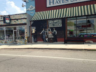
Back on the winding road, we passed through cute towns like Pacific, MO which calls itself "Train Town USA" and Cuba, MO which calls itself "The Mural City". I couldn't figure out why until I noticed on almost every block there was a giant mural such as this one.

those aren't real people, they're painted
When I stopped to get lunch, I passed right by Six Flags over St. Louis. I would love to take a tour of all the amusement parks and roller coasters in the USA. But file that under "Things I'll Do After River Dies". He would not enjoy that.
After about three hours, I had only gone about 100 miles and I was tired of searching and turning, so I turned on my navigation, hopped over to the Interstate and headed straight for the motel. I Route 66'd all the way to a town called Ralla, but from there into Springfield it was all I-44. Now that I see it on a map, I'm surprised to learn that 75% of my drive time was devoted to the first half of my total drive.

I kept seeing signs to Joplin and remembering that I had seen a documentary about that town, but I couldn't remember what it was. I thought it was a flood or an earthquake or a big storm; some natural disaster. I just looked it up, and it was a tornado in 2011. It was a spectacularly unheard of big and powerful tornado, if I remember correctly. I didn't make it to Joplin today.
Our last stop was at a rest area in Conway for River's feeding time on the grass. I was dripping sweat within just a few minutes of being outside. It was only like 91 degrees, but SO humid. I kept it brief and minimized the amount of running. When the weather gets like this, it gets increasingly harder to get River to jump back into the car after we've been lying on the grass.
Finally, at Springfield, I checked into the Motel 6. And like at the last location, also in Missouri, they were exceedingly friendly. And it seemed, genuinely friendly, not just customer service friendly. I do get the feeling, in general that the people in Missouri are very warm and friendly. I've had several conversations with strangers since being here, and I'm not actually the type to strike up conversations.
But here's something I noticed about the drivers in St. Louis. I'm driving down the street and they are waiting in a driveway to enter the road. As I approach them, they obviously want to pull behind me into the flow of traffic, but they start to inch out from the standstill before I've fully approached them. It always makes me feel like they're going to pull out and cause me to collide with them. It happened to me three times in St. Louis and I don't encounter that behavior anywhere else. Most people wait until the last car has cleared before starting to accelerate onto the main road behind it.
I did my laundry and walked River around the property.

The wind started to pick up during our walk. And the wind had a lovely, ominous cool swirl in it. Much of it was just the hot humid air, moving around, but occasionally I felt a vein of cool wash through. And I saw some big dark clouds in the direction that wind was coming from. The wind got more and more swift and the sky more and more dark as I wrapped up River's walk and quickly drove to the BBQ place to pick up my dinner. (read more about that here). I sat on the covered patio outside with River and ate. But still no rain. I got back in the car and the sky was fully grey and the wind furious. We were both safe inside the room for no longer than ten minutes when I heard a sound as if River were peeing on the floor. But he was just lying there. I looked out the window and torrents, lightning, thunder, big puddles in the parking lot. Sheesh. I'm glad we missed that. I plan to stay holed up in the room tonight, and see if this has passed by the morning.


Comments